How to import a Google Maps® route into Google Earth® - Save route to kml-file
| basics |
Google
Earth® (GE) allows
creating tours manually, but you cannot have GE
find routes. This you do with Google Maps®.
|
||
| How
To fly along a Google Maps route in Google Earth |
1. log into google (you
need to have a google account
/ login) 2. go to maps, create a new map (Menu: Your places, map, create map) 3. in the map add directions (icon on the right below search bar) 4. this creates a route from A to B like normally in maps 5. you can have several routes in one map 6. now click on the three dots in the very (!) top of the menu area 7. click on export to kml 8. select one route from the dropdown list (or select everything) 9. select export to kml 10. now it stores the route(s) in a kml file on your computer 11. double click on kml file should open kml file in Google Earth 12. now you should see your route in Google Earth 13. in the menu area, click on the path which is the route 14. in the lower right of the window with the path click on the play tour button THATS IT looks pretty amazing (if you have a good connection) |
minimum kml file for placemarks multiple placemarks in one file effect
of sea level change with Google Earth defining buildings in a kml file fix if kml-files from your server do not open in GE fix
if Google Earth does not connect to server
|
|
|
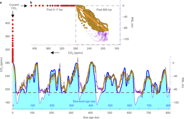
If you like this page, you can help us by clicking on our latest research paper in nature geoscience It is on CO2 release from continental shelves and you can read it for free here It has a wonderful graph that shows the relation between CO2 and sea-level during the last 800,000 years. This figure shows impressively how crazy our current CO2 levels are. You don't have to be a scientist to predict, where sea-levels might end up soon. |
 |
|